Module 7, Part A.
We created a folder structure on the computer. How cool is that. This was a connection section. We walked through the code process of creating a directory, adding file folders, and a simple tool box for scripts. It was good to see many little parts actually come together and be useful. If one needed to do this as a regular part of their job, this little code (which took several hours to do) can save days worth of time in a year for a company.
Part B. It's called the Describe Method (dsc). Really, its like pulling out parts & pieces out of a file layers properties. One can "call up" things like extent. Extent in the common world would be how wide and how deep a camera lens covers a panorama. One can ask the type of file- it is a line, polygon or dot( point) file, without having to go find it. Then again, we can ask through the code if the file we are looking for even exists- that is if you know it's name.
Part C. Do you like list? We learned to call up lists. There are list of nearly everything. Need a list of layers on a map, there's a list for that. Need to know how many data fields are in your map layer or even what they are without having to put up the file & thumb through them. Then the list thing is your thing to learn. Apparently, once mastered, it can be an enormous time saver.
Useful things were learned. Some code was written, some parts more successful than others.
Just when we start getting in the swing of the semester to learn real stuff, time is about to crunch on us with too much to learn, too little time.
Monday, July 30, 2012
Saturday, July 14, 2012
Local Government Applications - We Got 'hm" now! See that!!!
Seeing is believing. Our objective is to put learned mini skills to work checking out a county tax assessors website. A client has requested that an Environmental Impact Assessment (EIA) be conducted on his property. His objective is ultimately to evaluation the impacts of a "Fly-In Community" upon his adjacent property owners.
I'll not add all of our maps for this writing. But a couple would be helpful.
The basic steps taken were:
1- Isolate subject property.
2- Identify adjacent parcels.
3-Identify zoning of subject & adjacent parcels.
4-Identify EIA impact data (here limited to soil, census, zoning, roads, water, elevation, historical lots).
5- We also used this study to created a Map Index with data driven pages. (I've used these many many times with DOT right of way maps for title searches, now I know how they are created).
One of our basemaps looks like this:
 Ultimately, the client wanted to figure out a way to get his toys in and out of the house without being too much of an uninvited zoned neighbor.
The Marion County, Florida aerial enlarged on his parcel in red caught him. I've counted 3 toys of various sizes actually on the property. One can tell they are not part of the house structure by viewing the outline of the shadows. Does this guy, Danny Zuko, need a bigger garage or what? Pictures are usually worth a thousand words. This one may be worth several thousand in zoning violation penalties instead. "Got Him"

I'll not add all of our maps for this writing. But a couple would be helpful.
The basic steps taken were:
1- Isolate subject property.
2- Identify adjacent parcels.
3-Identify zoning of subject & adjacent parcels.
4-Identify EIA impact data (here limited to soil, census, zoning, roads, water, elevation, historical lots).
5- We also used this study to created a Map Index with data driven pages. (I've used these many many times with DOT right of way maps for title searches, now I know how they are created).
One of our basemaps looks like this:

The Marion County, Florida aerial enlarged on his parcel in red caught him. I've counted 3 toys of various sizes actually on the property. One can tell they are not part of the house structure by viewing the outline of the shadows. Does this guy, Danny Zuko, need a bigger garage or what? Pictures are usually worth a thousand words. This one may be worth several thousand in zoning violation penalties instead. "Got Him"

Wednesday, July 11, 2012
Debugging Python, Get a big can of RAID!
Writing a program is fairly simple, if you're writing one for a social event, planning a trip or some other pleasant occasion. Writing a computer program can be an adventure. Did anyone tell you that it had to be de=bugged if something goes wrong, and it will, you can count on it (song comes to mind here, several of them).
There are several better practices to writing a program. Think it out first, draw a picture, do a map (they call these model), ponder over it, then put it to paper. Whatever you write, save, save, save, (there's a local commericial out there for this one). Did I say save? Then run a few lines at a time, write yourself enormous notes using these little #### things. Tell yourself and others what you expect the program to give back to you for each section.
Type s l o w l y, and accurately. Looking for typing mistakes is called syntax errors. Finishing the lines of thought include punctuation ( [ " " ] } oops see there's one now. A syntax is running rampant. It should have looked like ( [ " " ] ). It's a good idea to study your file path. You need to know where you're going. Did you leave enough crumbs to follow? Draw a picture if you need to show how the flow of files, variables and pieces connect together.
A picture can show the next issue out there: no logic.
The most hidden of all things to fix are logical errors. Best said: well, I meant to say it this way but it came out the other.
Some logic errors are in the order of presentation. We need to tell the computer the definitions first before it can describe something. Others are in the methods. These are probably the hardest to find; especially for a newbie like me. I know nothing so how am I supposed to know that something was to go there when I knew nothing about it to begin with. For those of us who do not perform any math other than everyday things, verbalizing math on paper can be well .....................
Then there are the tools to help you find out your errors. Idle has a line by line thing which is good.
There's the pywin debugger which looks more window oriented. How it's applied I'm not really sure. Then there's the pdb thing. It's messy, maybe it works good, but how, I'm not able to tell you today. Maybe later when I'm more familiar with a little more practice.
There are bugs in python. Some are big, some are small. They can all be killed with RAID. But RAID will not make your program sing like a bird that a python would rather eat.
Enough for now. more later.
Tuesday, July 10, 2012
Looking for Dirt in Pike County, GA - (A participation exercise)
Georgia is not part of the PLSS (Public Land Survey System). God and the Cherokee Indians came to Georgia before anyone decided that map making or deed descriptions should have any rhyme or reason to them. Georgia being one of the original 13 colonies does it's own thing. This being said, it has 159 counties each having their own individual Tax Assessors' Office. Until fairly recently most counties were still making maps by hand and recording deed transfers by hand onto cards which were put into nearly fireproof file cabinets. We now have the Georgia Superior Court Clerk's Collaborative which indexes the recorded documents for the whole state. It was shoved down our throats so that a few rogue counties could not hide their federal tax liens in a bottom drawer and individual employees could not remove pages from the index book or otherwise walk out with the evidence that liens were filed against their family members. (Guess I know a few insiders).
The introduction of the computer has been a nearly wonderful invention for Georgia's property records. However, record keeping and computers work only as well as the programs are designed and as accurately as the information is erroneously entered by human hands who know little about
deed conveyances. Even as this is being written continuous errors of human nature are being permanently recorded in our deed records today.
Should I apologize for the tongue in cheek attitude? Maybe, but I refuse to. Most of my professional career has been spend in small, usually dark, horribly dusty county deed rooms looking for the left overs of piece of property that grandma had back when, over there by the creek described by lines only the writer could see in his dreams. Being able to interpret and draw survey blueprints has been my saving grace with my work. Writing metes & bounds descriptions beginning from nearly anywhere is a dying art now that satellites have come to see us from above.
Did you know that a rod, chain and cord are part of the legal description. Not so far back in time in many of these small counties where farms are being shredded into half-acre lots for the greedy one must absolutely be able to have an imagination to locate where the cow was slaughtered to find where the parcel description begins.
In realty now, lenders are not doing complete title searches which would go back in time at least 40 years, but only a current owner search on the computer in a foreign land not even connected to the continent they are researching. Times have changed. Processes have changed (almost). Liabilities haven't.
Now getting to this particular adventure in our GIS Applications class. Most Georgia counties have subscribed to qpublic.net a webbased program for listing property transfers. One must know at least some vital information to get into the system of searching. There is a somewhat interactive map after one has pulled up a parcel to view. Since we are still coming out of the dark ages into the computer world we think it's pretty cool. It's nothing like the fantastic website of Maricopa County, Phoenix, AZ. Whew! They really have something going. Now back to reality.
Here's a peek at Pike County, Georgia website for their Tax Assessor. It's quite typical for our state.

After you accept the statement that the information is not really up to date or accurate and you need to talk with a person to get the real scoop on the information, you can get into the system and see the list on the Right below. We're going to look at the sales for June, 2012.
 It's not a fancy system. Just put in the month 06/2012 to 07/2012 and you get these three small sales. Remember, real estate is horrible now. Foreclosures, deeds between family and other non-money swaps for property are not considered fair market sales so they do not show up as real sales. Fair enough but not completely accurate for the transfers of property.

You'll see that I put two screens together to get this. One can put the sales information in an excel sheet which could be handy. The top part has 3 sales for June. Two residential parcels and one commercial. Let's look at the subdivision lot in Whitfield subdivision. It's the largest sale for June, 2012. Look at the tax card below. It looks nearly like the paper printed version we would see on the card, Except you can see both sides on one screen. It leaves out the great little notes which made the difference with the personal touch of a human.
 This house is a typical 3 bedroom 2.0 bath, 1474 square foot house. It's about 3 miles or less from the school which is not typical in Pike County. It's in a real subdivision with covenants which is not that typical in Pike County. The lots are about 2 acres which they need to be to have a septic system because only parts of Pike County have access to public water. Only the City of Zebulon has sewer facilities. The history of this piece is typical of the fast growing nature of our county. The lot was purchased by Ark Builders (friends of mine). This was one of the last they built as a spec house. (House built in anticipation of a buyer rather than one on specific contract for a buyer in waiting).
The original house new was sold at 147,500, fairly typical for the area, 2001, at the top of the building frenzy in the area. It was sold 2005 for a small profit $154,900. The new owners had a divorce, and it was sold in 2012 for a significant loss. Values are typical of the area with nearly a
30-50 percent decrease in value for property. The seller was lucky here. The property being in a desired subdivision, close to the school, close to town made a major difference in the reduced loss on the sale
I've been in the real estate business over 25 years. Each piece of property can tell you a story. This one is no different.
Let's look at another piece of property, with which I'm familiar. Mr. Van's place. He had owned the vacant acres since 1976, transferred it to various family members over time. Dreamed about building a house there for his retirement. Let's look at his property card.

He built the house in 2001. The card tells you that it is a one story house without an attic. Pay attention here. It has a basement with over 2200 square finished feet. If we looked at the drawing we would only see the first level, not the basement. So what's down there. If you knew a little about Mr. Van you would learn real quick that he is a master tile man. His whole house upstairs and down in the basement is completely finished in exquisite tile work. Now do you understand a little about how the value of this 5 acre property has such an expensive house in a neighborhood with trailers and less than starter homes. Another fact, Pike County has a complete volunteer fire department, no county water lines run for fire protection. Mr. Van's house is less likely to burn down as a fire hazard.
Let's look now at the property parcel map & I'll let you in on a secret or two that I've learned over the years doing property searches.

 Mr.Van's five acres are highlighted in red. He actually owns the piece which surrounds it to the left and south. Look closely, do you see the triangle piece. It's on the next picture in red. It's actually a land locked piece that the county assessor has no idea who owns it. In reality, it's Mr. Van's. He for some unknown reason chose to record an odd plat with the county which left it hanging. I know this because I've done the title search on his property which had to be taken back to 1922 into the old civil suit records to get a clear title.
Notice something else. The property lines follow a creek. Very Typical. Many of these parcels are perfect rectangles. Very typical in a rural county where you had family owned tracts held for long periods of time before the patriarch of the family would subdivide the property to his children.
Mr. Van's piece is no exception.
WELCOME TO THE WORLD OF GEORGIA TITLES. Want to know a little dirt. Read the property card. Family history, family tragedy, family problems, all in print right there for you to see.
PART 2 OF THIS ADVENTURE.
Switching gears completely. Let's travel to Escambia County, Florida. The goal is to review property assessments for a particular subdivision known as West Ridge Place. Here's a map of the subdivision which reflects very recent assessed data. We were not given the actual dates of the latest assessment so it's not on the map. Most likely its 2010 or 2011 depending on when the county's assessment comes out.

Notice the different colors for the parcels, particularly the reddish one the light orange and nearly yellow in color. The majority of this fairly new subdivision is assessed at 27, 075 per lot. So why are there differences in the remaining eight lots. Don't know. Each of these 8 need to be reassessed. The red to find out why it is rated so high. Was it recently sold at a premium price because someone just absolutely had to have it? How about the yellow on the entry corner. It's rated much lower than the twin sister lot on the adjoining corner. Is there something particularly different about it? Otherwise it should most likely be assessed higher. Then there are the remaining lots inside the subdivision which are rated lower. Only one is on an easement which doesn't appear to be a hindrance. Other lots are also on similar easements with no effect on their value.
Color coding made a clear difference in this evaluation case. An uneducated eye can see there are
differences between the lots. Concluding: reevaluation is needed for those lots shown in red, yellow and light orange.
Have a great day. Look where you are going. Information is up ahead.
Karen Mathews
The introduction of the computer has been a nearly wonderful invention for Georgia's property records. However, record keeping and computers work only as well as the programs are designed and as accurately as the information is erroneously entered by human hands who know little about
deed conveyances. Even as this is being written continuous errors of human nature are being permanently recorded in our deed records today.
Should I apologize for the tongue in cheek attitude? Maybe, but I refuse to. Most of my professional career has been spend in small, usually dark, horribly dusty county deed rooms looking for the left overs of piece of property that grandma had back when, over there by the creek described by lines only the writer could see in his dreams. Being able to interpret and draw survey blueprints has been my saving grace with my work. Writing metes & bounds descriptions beginning from nearly anywhere is a dying art now that satellites have come to see us from above.
Did you know that a rod, chain and cord are part of the legal description. Not so far back in time in many of these small counties where farms are being shredded into half-acre lots for the greedy one must absolutely be able to have an imagination to locate where the cow was slaughtered to find where the parcel description begins.
In realty now, lenders are not doing complete title searches which would go back in time at least 40 years, but only a current owner search on the computer in a foreign land not even connected to the continent they are researching. Times have changed. Processes have changed (almost). Liabilities haven't.
Now getting to this particular adventure in our GIS Applications class. Most Georgia counties have subscribed to qpublic.net a webbased program for listing property transfers. One must know at least some vital information to get into the system of searching. There is a somewhat interactive map after one has pulled up a parcel to view. Since we are still coming out of the dark ages into the computer world we think it's pretty cool. It's nothing like the fantastic website of Maricopa County, Phoenix, AZ. Whew! They really have something going. Now back to reality.
Here's a peek at Pike County, Georgia website for their Tax Assessor. It's quite typical for our state.
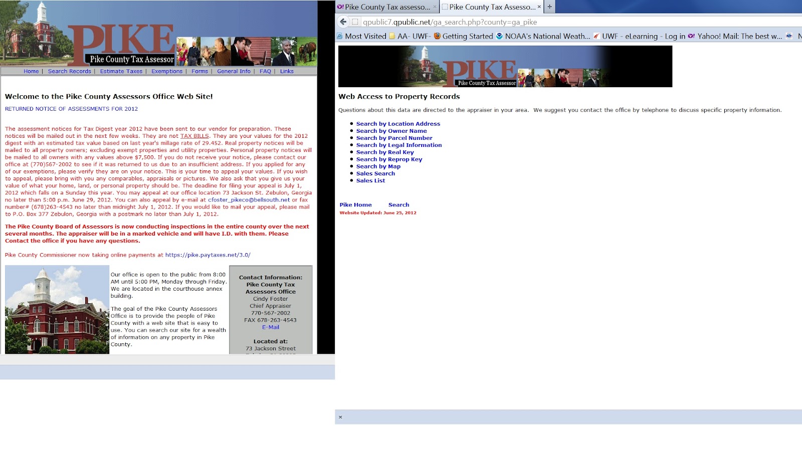
After you accept the statement that the information is not really up to date or accurate and you need to talk with a person to get the real scoop on the information, you can get into the system and see the list on the Right below. We're going to look at the sales for June, 2012.


You'll see that I put two screens together to get this. One can put the sales information in an excel sheet which could be handy. The top part has 3 sales for June. Two residential parcels and one commercial. Let's look at the subdivision lot in Whitfield subdivision. It's the largest sale for June, 2012. Look at the tax card below. It looks nearly like the paper printed version we would see on the card, Except you can see both sides on one screen. It leaves out the great little notes which made the difference with the personal touch of a human.

The original house new was sold at 147,500, fairly typical for the area, 2001, at the top of the building frenzy in the area. It was sold 2005 for a small profit $154,900. The new owners had a divorce, and it was sold in 2012 for a significant loss. Values are typical of the area with nearly a
30-50 percent decrease in value for property. The seller was lucky here. The property being in a desired subdivision, close to the school, close to town made a major difference in the reduced loss on the sale
I've been in the real estate business over 25 years. Each piece of property can tell you a story. This one is no different.
Let's look at another piece of property, with which I'm familiar. Mr. Van's place. He had owned the vacant acres since 1976, transferred it to various family members over time. Dreamed about building a house there for his retirement. Let's look at his property card.

He built the house in 2001. The card tells you that it is a one story house without an attic. Pay attention here. It has a basement with over 2200 square finished feet. If we looked at the drawing we would only see the first level, not the basement. So what's down there. If you knew a little about Mr. Van you would learn real quick that he is a master tile man. His whole house upstairs and down in the basement is completely finished in exquisite tile work. Now do you understand a little about how the value of this 5 acre property has such an expensive house in a neighborhood with trailers and less than starter homes. Another fact, Pike County has a complete volunteer fire department, no county water lines run for fire protection. Mr. Van's house is less likely to burn down as a fire hazard.
Let's look now at the property parcel map & I'll let you in on a secret or two that I've learned over the years doing property searches.


Notice something else. The property lines follow a creek. Very Typical. Many of these parcels are perfect rectangles. Very typical in a rural county where you had family owned tracts held for long periods of time before the patriarch of the family would subdivide the property to his children.
Mr. Van's piece is no exception.
WELCOME TO THE WORLD OF GEORGIA TITLES. Want to know a little dirt. Read the property card. Family history, family tragedy, family problems, all in print right there for you to see.
PART 2 OF THIS ADVENTURE.
Switching gears completely. Let's travel to Escambia County, Florida. The goal is to review property assessments for a particular subdivision known as West Ridge Place. Here's a map of the subdivision which reflects very recent assessed data. We were not given the actual dates of the latest assessment so it's not on the map. Most likely its 2010 or 2011 depending on when the county's assessment comes out.

Notice the different colors for the parcels, particularly the reddish one the light orange and nearly yellow in color. The majority of this fairly new subdivision is assessed at 27, 075 per lot. So why are there differences in the remaining eight lots. Don't know. Each of these 8 need to be reassessed. The red to find out why it is rated so high. Was it recently sold at a premium price because someone just absolutely had to have it? How about the yellow on the entry corner. It's rated much lower than the twin sister lot on the adjoining corner. Is there something particularly different about it? Otherwise it should most likely be assessed higher. Then there are the remaining lots inside the subdivision which are rated lower. Only one is on an easement which doesn't appear to be a hindrance. Other lots are also on similar easements with no effect on their value.
Color coding made a clear difference in this evaluation case. An uneducated eye can see there are
differences between the lots. Concluding: reevaluation is needed for those lots shown in red, yellow and light orange.
Have a great day. Look where you are going. Information is up ahead.
Karen Mathews
Friday, July 6, 2012
Homeland Security- More than meets the eye
this is the end of a two part series on Homeland Security. We have been learning about the requirements set out in the National Preparedness Guidelines established by the Homeland Security Presidential Directive 8 (HSPD-8) from 2003. There are many uses for GIS, however, there are an amazing number of applications just in the realm of HLS.
Did you know that there are 1600 unique tasks on the Universal Task List and 37 specific capabilities that communities need to have established for effective disaster response?
We learned there are eight basic base sets of information needed which are GIS based for effective response. Instead of spending our time downloading the base maps, we were graciously provided base maps to work with in a surveillance setup for Norad, Cheyenne Mountain, Colorado.
Here's a map or two show casing part of our study. A powerpoint presentation is at the end.
 This one is good because it focuses on the
need to know the populated zones for
protected areas. Who can be affected?
It also shows cool colors for the elevation of
Cheyenne Mountian.
 AhHHH Ohhh, the adventures of using 3D
stuff. It took 5 startups to get these results.
Flying in 3d is not as easy as it looks on TV.
 This bird looking thing is all I could get
out of the 3d part for setting up my projected
line of sight points.
Enjoy the powerpoint presentation. It pulls together our work for these two sessions.
Ok gotta figure out how to attach it to work. Back soon.
Back here with a pdf version of the powerpoint.
https://skydrive.live.com/redir?resid=1C4BF7367A63292!117&authkey=!AHVA5RVom4pfAvs
Did you know that there are 1600 unique tasks on the Universal Task List and 37 specific capabilities that communities need to have established for effective disaster response?
We learned there are eight basic base sets of information needed which are GIS based for effective response. Instead of spending our time downloading the base maps, we were graciously provided base maps to work with in a surveillance setup for Norad, Cheyenne Mountain, Colorado.
Here's a map or two show casing part of our study. A powerpoint presentation is at the end.

need to know the populated zones for
protected areas. Who can be affected?
It also shows cool colors for the elevation of
Cheyenne Mountian.

stuff. It took 5 startups to get these results.
Flying in 3d is not as easy as it looks on TV.

out of the 3d part for setting up my projected
line of sight points.
Enjoy the powerpoint presentation. It pulls together our work for these two sessions.
Ok gotta figure out how to attach it to work. Back soon.
Back here with a pdf version of the powerpoint.
https://skydrive.live.com/redir?resid=1C4BF7367A63292!117&authkey=!AHVA5RVom4pfAvs
Subscribe to:
Posts (Atom)